 |
|
|
| |
| |
Tips And Tricks |
|
| |
| Tips And Tricks 01 |
| |
Technical Tip: Choosing the Correct Flight Plan in VR-Forces
Fixed-wing aircraft in VR-Forces support the basic movement tasks, such as Move to Waypoint and Follow Route. They also havemovement tasks specific to their platform. In particular, there are several ways to change altitude. Understanding the differencesbetween these tasks can help you make the best use of them. |

Figure 1
|
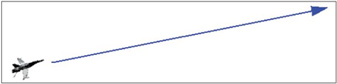
Figure 2
|
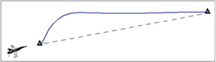
Figure 3
|
- If you tell a fixed-wing entity to Move to Altitude, it spirals to the new altitude and then loiters at that location (Figure 1).
- If you tell a fixed-wing entity to Fly Altitude, it rises or descends to the new altitude at its current heading at a specifiedclimb rate (Figure 2). Fly Heading and Altitude lets you specify a change in heading while it changes altitude. In either case, when it reaches the new altitude, it continues to fly at the new altitude at the current heading.
- If you tell a fixed-wing entity to Move to Waypoint or Follow Route (routes are just a series of waypoints) and there is achange of altitude between the current location and the next waypoint, the entity immediately rises or descends to thealtitude of the destination point and then flies to the destination (Figure 3). When it reaches the final destination, it loitersat that location.There are a few more ins and outs to fixed-wing flight tasks and behaviors. You can get all the details in the Tasks chapter in VR-ForcesScenario Management Guide.
|
| |
| Tips And Tricks 02 |
| |
| Technical Tip: How To See More Terrain with CDB |
| |
A common question for our Vega Prime support team is: How can I see more terrain with my CDB database?
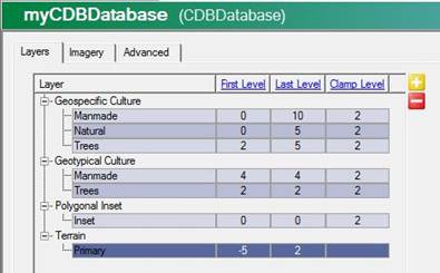
In myCDBDatabse, set the First Level of Terrain to -5. This will cause coarser terrain to be loaded beyond the limits of the LODs usually loaded. This is a feature unique to CDB that is not possible with MetaFlight databases, and is the recommended approach because it should have little impact on performance. |
| |
 |
| |
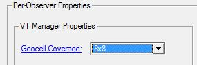
| Also, the VT coverage will need to be extended. You can change this setting in the Imagery tab in myCDBDatabase. Change the Geocell Coverage to a higher value like 8x8. A 16x16 setting would be good for a huge far clip (such as 700000 or more). |
| |
 |
| |
| Another change that helps is to adjust the paging distance multiplier for the terrain as well as the visibility range scale. Normally, these two values should be adjusted together, and the visibility range scale should be the inversion (1/x) of a value slightly less than the page distance multiplier. For example, values of 1.5 (pdm) and 0.8 (vrs) would be good and would result in seeing all LODs at longer distances. However, this will have a greater impact on performance. |
| |
| |